A Cold Week On Tap For Washington, High Winds Into Tuesday
Overnight lows will be near or below freezing in most areas this week, and a wind advisory begins Monday night.
By Lucas Combos, Patch Staff
Oct 28, 2019 2:59 pm ET | Updated Oct 29, 2019 12:20 pm ET | Courtesy of Patch.com

A colder-than-normal week will see high winds Monday night and Tuesday. (Shutterstock)
SEATTLE, WA — October will leave us on a chilly note this week, with overnight lows forecasted near or below freezing and a blustery night expected Monday into Tuesday. According to the National Weather Service, gusts in Seattle and Tacoma are projected in the 20-25 mph range, but the highest winds are expected in the Cascade Foothills and East Puget Sound Lowlands. Enumclaw and North Bend are expected to see gusts in the 40 to 50 mph range.

According to NWS Seattle, gusts will create difficult driving conditions for high-profile vehicles, and the possibility of some downed trees or branches could spur localized power outages. Everyone is encouraged to secure outdoor objects and take precautions to prepare property for freezing conditions. A wind advisory began at 10 p.m. Monday, but winds are expected to ease Tuesday afternoon.
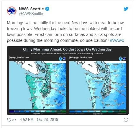
Temperatures recorded Monday morning were already several degrees below normal. Lows Tuesday morning were forecast at 29 degrees for Tacoma, 34 degrees for Seattle and 30 degrees for Everett, with temperatures in the mountain passes projected in the teens. Forecasters said the windchill factor Tuesday morning could land in the 15 to 25-degrees range in many areas. Wednesday morning will be even more frigid, with lows in Tacoma at 20 degrees and 28 degrees in Kent, Seattle and Everett.